
Wednesday, February 06, 2013
BLIZZARD OF 2013 INCOMING

History in the Making...

UPDATE (Feb. 6, 2013 - 5PM) Blizzard watches are in effect for eastern Massachusetts currently. We have ourselves a historic storm in the making. Above is the latest NWS estimate of snowfall accumulations (18-24"). To tell you the truth, I would not be surprised to see 30"+ in some locations. We are entering hallowed ground here folks. Keep attuned to the news and weather websites.
Here is the latest bulletin from the NWS:
...BLIZZARD WATCH IN EFFECT FROM FRIDAY MORNING THROUGH SATURDAY
AFTERNOON...
...WINTER STORM WATCH IS CANCELLED...

THE NATIONAL WEATHER SERVICE IN TAUNTON HAS ISSUED A BLIZZARD
WATCH...WHICH IS IN EFFECT FROM FRIDAY MORNING THROUGH SATURDAY
AFTERNOON. THE WINTER STORM WATCH HAS BEEN CANCELLED.

* LOCATIONS...MUCH OF EASTERN MASSACHUSETTS AS WELL AS NORTHERN AND
  CENTRAL RHODE ISLAND. THIS INCLUDES THE BOSTON TO PROVIDENCE
  CORRIDOR.

* HAZARD TYPES...HEAVY SNOW WITH THE POTENTIAL FOR BLIZZARD
  CONDITIONS.

* ACCUMULATIONS...SNOW ACCUMULATION OF 12 TO 24 INCHES.

* TIMING...LIGHT SNOW DEVELOPS BY FRIDAY MORNING. SNOW WILL
  INCREASE INTENSITY DURING FRIDAY AFTERNOON. THE HEAVIEST SNOW
  WILL OCCUR FRIDAY NIGHT INTO SATURDAY MORNING.

* IMPACTS...HEAVY SNOW AND STRONG WINDS WILL BRING THE POTENTIAL
  FOR BLIZZARD CONDITIONS. THE WORST OF THE STORM WILL BE FRIDAY
  NIGHT INTO SATURDAY MORNING. SNOWFALL RATES OF 2 TO 3 INCHES PER
  HOUR POSSIBLE. TRAVEL MAY BECOME NEARLY IMPOSSIBLE WITH BLOWING
  AND DRIFTING SNOW.

* WINDS...NORTHEAST 25 TO 35 MPH WITH GUSTS UP TO 55 MPH.

* VISIBILITIES...ONE QUARTER MILE OR LESS AT TIMES.

* TEMPERATURES...IN THE MID 20S.


PRECAUTIONARY/PREPAREDNESS ACTIONS...

A BLIZZARD WATCH MEANS THERE IS A POTENTIAL FOR CONSIDERABLE
FALLING AND/OR BLOWING SNOW WITH SUSTAINED WINDS OR FREQUENT
GUSTS OVER 35 MPH AND VISIBILITIES BELOW 1/4 MILE FOR AT LEAST
3 HOURS. WHITE OUT CONDITIONS WILL BE POSSIBLE...MAKING TRAVEL
VERY DANGEROUS.  BE PREPARED TO ALTER ANY TRAVEL PLANS.
STAY TUNED!!!
Monday, January 21, 2013
Localized Snowstorm

Regardless, snows break out in western New England by early afternoon and overspread the area during the overnight. The heaviest snow for eastern sections will occur between midnight and 3AM. Snow tapers for all by sunrise. My guess is for school for 95 percent of communities tomorrow. Updates throughout the day as needed.
Sunday, January 20, 2013
FIRST CALL for Tuesday AM

FIRST CALL (SUN. 1PM) --- Here is my first call for this complex inverted trough scenario. We won't know exactly where the heaviest of snows are until this event is underway basically, so expect a wide range of forecasts for this one. Some TV outlets may be calling for 6"+ in Boston and E MA, while others merely forecast an inch or two. This is my call right now. I think somebody in E MA does very well, while others (some who are even in the 4-8" shading!) only get a couple inches.
And guess what? More snow is in the forecast for Friday. But before that we will have to deal with sub zero mornings in the 'burbs Wednesday and Thursday morning. Wind chills could be -10F to -15F in SNE! Get ready. It's coming.
Prepare for 4 Day Weekend Inside Route 495

Saturday, January 19, 2013
Disaster Tuesday AM Commute?
I am waiting on a few more runs of the models before providing more details, but guidance is trending toward a potentially significant snowstorm (esp. for eastern SNE) Monday night into Tuesday. Our snow would come from a developing low pressure system off of Nantucket that throws snow back into SNE from a 'Norlun' front. Norlun fronts can be difficult to forecast. They often have a narrow band of heavy snow with much lighter snows on either side of it. Wherever that front stalls, the potential exists for over 6 inches of snow. Some models have that feature over the ocean, while others give the Boston metro area over a foot of fluffy snow. We'll have to watch this one closely. Expect it to come into clearer focus by tomorrow afternoon. Maybe by then I will be confident enough to put up a map with my first thoughts. Lastly, GO PATS!
Wednesday, January 16, 2013
A Southeastern Mass Snowy Surprise Thursday Night?
It looks like my forecast for this past storm worked out pretty well. Most of SNE (away from the Cape and islands) saw a general 2-5" of snow with this system. The accumulating snow has tapered and we will be left with drizzle and snizzle for the rest of the afternoon. Clearing by tonight.
Then we turn our eyes down into the southeastern states where our next storm is taking shape. This storm looked to develop off the Carolina coast and then meander offshore, leaving SNE high and dry. However, recent trends (most notably the GFS and NAM) are bringing this closer to our shoreline on Saturday. Recent model runs even bring measurable snow all the way to the northwest suburbs of Boston! I am not saying that it is going to make it that far NW (yet), but the potential is there especially for southeastern zones. Anyone from Plymouth-points south and east should prepare for at least a couple of inches out of this one. We will watch the trends closely to see if this threat gets any closer to Boston. For now, I would lean towards mostly dry in the city and nearby suburbs. Lots to figure out though. I may do an update later this afternoon or tonight if this becomes more of a threat. Also, if it holds, I will be issuing my first call snowfall accumulation map by tomorrow afternoon too.
This is going to be a tricky forecast to say the least.
Then we turn our eyes down into the southeastern states where our next storm is taking shape. This storm looked to develop off the Carolina coast and then meander offshore, leaving SNE high and dry. However, recent trends (most notably the GFS and NAM) are bringing this closer to our shoreline on Saturday. Recent model runs even bring measurable snow all the way to the northwest suburbs of Boston! I am not saying that it is going to make it that far NW (yet), but the potential is there especially for southeastern zones. Anyone from Plymouth-points south and east should prepare for at least a couple of inches out of this one. We will watch the trends closely to see if this threat gets any closer to Boston. For now, I would lean towards mostly dry in the city and nearby suburbs. Lots to figure out though. I may do an update later this afternoon or tonight if this becomes more of a threat. Also, if it holds, I will be issuing my first call snowfall accumulation map by tomorrow afternoon too.
This is going to be a tricky forecast to say the least.
Monday, January 14, 2013
Snow Map for Tomorrow Night

FIRST CALL - I'm not tremendously bold with this one for being a significant snow maker for the area, but we should see advisories hoisted for interior zones. I'm calling for a general 2-4" of snow with perhaps a town or two (esp. a hill town) to finish with a 5" amount. Closer to the city, we will have to battle with the warm Atlantic Ocean. SST's are still in the low 40s, so that will do its best to keep the surface warm near the coast. The biggest wildcard on this map would have to be inside of 495. As depicted, I have this area shaded in with 1-3". However, if the winds remain mostly calm, then the ocean will have less of an effect and therefore snow accumulations would be more like interior zones right to the coast. Boston will likely have trouble regardless, but as close by as Cambridge or Somerville would be able to pick up a few pasty inches of snow. Further SE over the Cape and islands - I am expecting mostly rain with this one. Perhaps they can get some wet, non-accumulating snow, but it would be tough to get anything more than that. If anything changes tonight, I will touch up the map as needed. For now though, I think this is a fair depiction of what will take place.
Warmth Departing, Snow Incoming?
Lots to talk about, but I am going to wait until early this afternoon before posting about snow possibilities - likely Tuesday night into Wednesday. I hope you enjoyed the springtime warmth too. As I am typing this just before 9AM, it is 54 degrees outside. It may be a while before we see a morning this warm again.
------
5PM UPDATE - Everything seems to be coming together for plowable snows for much of SNE tomorrow night and early Wednesday morning. This will not be a blockbuster, but some spots could pick up a few inches that would make the Wednesday morning commute a bit of a headache. All of the computer models are hitting the Mass Pike corridor for heaviest precipitation, but the question remains what type will it be? The European model is the coldest and the American GFS was the warmest at noon, pushing the rain/snow line up to the Pike, including Boston and the immediate coast.
I think those away from the immediate coast and away from the south coast, Cape, and islands will likely stay mostly snow with this one. I am working on a snow map now, but waiting for the GFS to come out over the next hour before putting numbers up. I am feeling a general few inches for most of the area. Nothing we can't handle. Still, it will be a shock to the system after many towns soared into the low 60s this afternoon.
Next update with the snowfall accumulation map (first call) around 6PM.
------
5PM UPDATE - Everything seems to be coming together for plowable snows for much of SNE tomorrow night and early Wednesday morning. This will not be a blockbuster, but some spots could pick up a few inches that would make the Wednesday morning commute a bit of a headache. All of the computer models are hitting the Mass Pike corridor for heaviest precipitation, but the question remains what type will it be? The European model is the coldest and the American GFS was the warmest at noon, pushing the rain/snow line up to the Pike, including Boston and the immediate coast.
I think those away from the immediate coast and away from the south coast, Cape, and islands will likely stay mostly snow with this one. I am working on a snow map now, but waiting for the GFS to come out over the next hour before putting numbers up. I am feeling a general few inches for most of the area. Nothing we can't handle. Still, it will be a shock to the system after many towns soared into the low 60s this afternoon.
Next update with the snowfall accumulation map (first call) around 6PM.
Wednesday, January 09, 2013
2012 = Warmest Ever

NOAA Press Release on Jan. 8, 2012:
According to NOAA scientists, 2012 marked the warmest year on record for the contiguous United States with the year consisting of a record warm spring, second warmest summer, fourth warmest winter and a warmer-than-average autumn. The average temperature for 2012 was 55.3°F, 3.2°F above the 20th century average, and 1.0°F above 1998, the previous warmest year.
Wintertime cold returns midweek, next week. Enjoy the spring warmth for now.
Sunday, January 06, 2013
Early Look at Kickoff Next Sunday...

We are a week away from kickoff at Gillette of the AFC Divisional playoff game. If you're lucky enough to have a ticket, you may ask what is the weather going to be like at Foxboro. Normally in mid January, you would expect bitter temperatures or maybe even a snow bowl like in 2001 against the Oakland Raiders. Well, neither look to be in the cards for this year. After sustaining a solid snow pack for about 1-2 weeks across much of SNE, a massive January thaw arrives by Tuesday and likely peaks right around the end of next weekend, just in time for the Texans to arrive at the Gillette. In fact, the Houston players may think that they never actually left Texas in the first place because we could easily be talking middle 50s if not slightly over 60 degrees by Sunday afternoon!
EARLY GUESS GAME TIME CONDITIONS
4:35PM - Sunday, January 13th
------------
Kickoff: Mid-Upper 50s Dry
Halftime: Lower 50s Dry
End: Upper 40s Dry, Slight Risk Shower
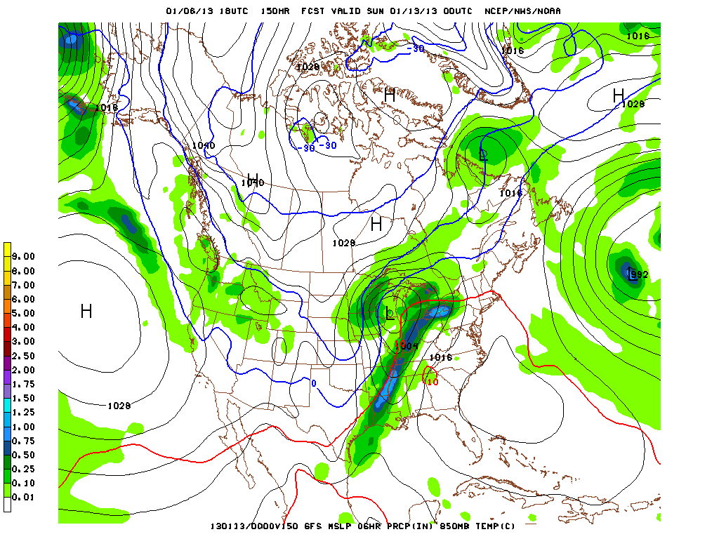
I do not have time to post later images from the GFS, but I want to drive home the point that this warmth will NOT last. It is in here for a 6-8 day stint. Tomorrow will likely be in the middle 30s and then we are in the 40s through Friday before pushing 50 on Saturday and then 60 on Sunday. Thereafter we really start to cool down and by the middle of next week after the warmup, we will likely be back to 20s/30s for high temperatures. It still remains to be seen how much snowfall we will see in the new pattern, but we should be able to increase the chances somewhat just with having cold air around. Most importantly, nearly every computer model (GFS, EURO, GGEM, etc.) agree that this warmup will be short-lived and that winter is far from over. In other words, enjoy the warmth while you can this week.
Monday, December 31, 2012
Quiet Week Ahead, January Thaw Imminent
I don't have much time to get into the details, but it looks like this week will be slightly below normal (temperature-wise) with mostly dry conditions. We may get a flurry or two tonight to ring in the new year, but other than that, don't expect much. Then indications exist that show much of the country warming up. The Great Plains will certainly turn much above normal, while we are left on the envelope of the warmth. Maybe we can get a snow chance yet?
Have safe and happy new year's celebrations tonight!
Have safe and happy new year's celebrations tonight!
Saturday, December 29, 2012
FINAL CALL: Saturday Snow

(12:00PM / 12-29-12) I updated the snowfall map from last night and really bumped up totals for eastern Massachusetts. Inside of Route 495 will really get pounded tonight with 1-2"/hr. snows for a few hour period. The coastal low is now taking over off the Delmarva and really looks impressive on satellite imagery. Also, the computer models (all of them) strengthen the storm tremendously ("bombogenesis") and push that comma head of most intense snows and wind over eastern Mass. This is why I had to increase totals to 6-10" in that heaviest band. SE of it, there will likely be more precipitation (QPF), but it will be warmer and they will have to contend with precipitation type issues for the beginning of the storm. NW of Plymouth, you should remain mostly if not all snow. This is the biggest storm in eastern Mass in over 2 years, so please take it easy out there later tonight. Our winter driving skills haven't been tested in a long time. Take care.
(11:55PM / 12-28-12) Here is my last call for tomorrow's snow. Computer models came in a little 'juicier' today, forcing me to increase totals across the board today. I like interior SE MA, eastern CT, and northern RI for the jackpot area (4-8"). Most areas will likely come in on the lower end of these totals, but it would not shock me if a few towns finished on the higher end. The one wildcard is the Cape. If they somehow avoid mixing or starting as rain, then they could be off to the races and that 2-5" call would be extremely conservative. However, it looks like they will be dealing with precipitation type issues throughout the storm until the very end. Overall, the further N&W you go, the fluffier the snow. The closer to the coast and SE MA you go, the more pasty the snow will be.
Start time is from 10AM to 2PM from SW to NE. Expect it to end some time overnight Saturday or the wee hours of Sunday morning. Clearing through the morning hours Sunday and a cold Pats game at 4PM at Gillette. The real Arctic arrives later next week. By next Friday, high temperatures could struggle to get out of the TEENS with lows BELOW ZERO in the suburbs. Welcome to winter! It's been missing in action for the past two years, but I think it's almost safe to say that it is back and with a vengeance.
Friday, December 28, 2012
Snow Potential Saturday

Thursday, December 27, 2012
Finally a SNE Snowstorm to the Coast En Route?
Possible....More on this later tonight, but pinpointing Saturday night into Sunday for potential significant snows to affect all of SNE including the Cape and islands.
Wednesday, December 26, 2012

FINAL CALL: There are two camps with this system - (1) the warm/rainer camp and (2) the colder, snowier camp. Of course the computer models that the TV weathermen use are showing any snow quickly changing to rain, while the much more reliable EURO computer model continues to show impressive snow just outside of Boston. I'm taking the warmer route just because the NWS is so conservative with this one and likely for good reason. I've pushed the heaviest snow amounts NW and dramatically cut any accumulations for the vast majority of SE NE. I think the changeover line will only make it to about Manchester, NH - Orange, MA - Pittsfield, MA. NW of there, the storm should be primarily snow. SE of there, fair game for freezing rain, sleet, and plain rain.
Again, this map has extreme bust potential either way. If we can get the precipitation in here quick enough, we can get significant accumulations right inside 128. If not, I think we will have a map that looks something like this. On a side note, it now appears that the weekend threat will slide out to sea, maybe scraping the Cape with some light snow or flurries. Plenty of time for that one to change.
Tuesday, December 25, 2012
A Messy Midweek Storm

All snow will be confined to the northern mountains where over 12 inches of snow is highly possible. But as you can see, heavy snowfall accumulations will reach all the way down into the NW half of Middlesex County and most of Worcester County through the Berkshires. (Where 6-12" of snow is possible). Inside 495, the warm Atlantic will likely warm the surface more quickly, limiting accumulations to 3" to as much as 6" (best chance for higher amounts further inland, while somewhere like Boston right on the shore gets more like 1-2", maybe 3").
I will post my final accumulation map tomorrow morning and have more detailed information about start and changeover times. Again, Merry Christmas to those who celebrate! We may be able to muster up another storm by the end of this weekend too. More on that potential snow later.
Update on BIG Storm Later Today...
Merry Christmas! I will have an important update of the impressive storm that will be slamming our area beginning tomorrow night and last through Thursday. SPOILER ALERT - the low now looks to be tracking south of SNE and across Nantucket before exiting off into the maritimes. Good news for snow lovers! More later.
Sunday, December 23, 2012
Festive Christmas Snow

The storm for the 27th and 28th still looks like a big rainstorm and the models have been pretty consistent in showing that storm as such. More details on that after we move past this low-impact event on Christmas Day.
Saturday, December 22, 2012
Christmas Day Snow - An Early Look
UPDATE (12/22 - 5PM) - What a horrible run of the models today for snow lovers. After last night's overnight EURO run dropping high-end advisory to low-end warning snows along the Mass Pike right into Boston, today's EURO nearly dropped the system off the radar - pun intended. Now the early evening model runs are also showing this system losing steam as it heads out of the OH Valley and through PA. Because of the weaker life and lower rates, it will likely warm into the middle 30s during the daytime on Christmas Day too, which will also limit accumulations near the coast. Perhaps the Worcester Hills could still be able to pick up an inch or two, but even that might be generous with the unfortunate trends today. We are still about 60-72 hours away, so the models could turn back to the snowier/more amplified scenario later tonight or during tomorrow. However, in my experience, once these start to trend weaker at the 'last minute', then we probably will not return to the solutions that were giving much of the region a few to several inches of snow overnight Christmas Eve and Christmas Day morning.
We still have the late week system too though? Sorry to be the bearer of bad news, but all computer models are focusing on that system to amplify rather quickly once it is in the TN Valley. Consequently, there is not much of a handoff to the secondary that 'was' developing off the Mid Atlantic coast in previous days' runs. Also, the high pressure system to the north of us is weaker and further west (north-northwest) too, which also allows this thing to push up the spine of the Apps. A secondary low pressure surface reflection tries to show later in the game near NYC, but even that gets pulled WNW on most of the computer models, flooding much of SNE with warm maritime air that changes any brief period of snow at the onset to heavy rain with strong southeasterly winds. Even ski country might have a hard time dodging the rain drops with this one if it verified as depicted on the models today. This one is still about 4.5 to 5 days out, so we still have time to work on the details, but the trend is definitely not our friend (if you're a snow lover anyway).
Last minute shopper? Tomorrow should be a fine day (weather-wise at least) to get to the malls.
 |
| 00z GFS - 12-22-2012 |
I am updating the blog from last night's optimism regarding the potential snow for Christmas Day. Well, it now appears more likely after tonight's late hour model runs. Last night's EURO run and this afternoon's EURO run gave much of SNE several inches of snow, away from the Cape and Islands. Now the American model (GFS) is coming on board with a snowier solution too as depicted above.
The GFS still keeps this as mostly a Pike-south event, but the EURO (admittedly a more reliable model) gets at least a few inches up across the MA/NH border. Right now I would have to go in the middle of the two, but tend to favor the EURO solution. The newest EURO solution comes out at 1:15AM, so we will have to wait and see if it keeps the Christmas Day snow hope alive. The trends are encouraging for snow lovers this evening though across all fronts. The snowier models are giving this low pressure system time to develop and amplify off the NJ/LI coasts, so this will only contribute to a widening snow band that reaches across much of SNE.
Subscribe to:
Posts (Atom)