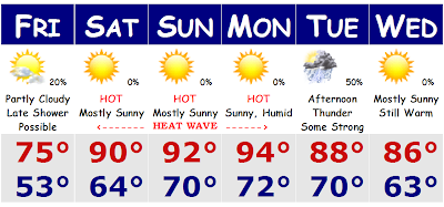
SATURDAY- We have got ourselves a steamy, warm, and wet couple of days ahead for SNE. It seems we have been stuck in an unsettled regime with constant threats for showers and thunderstorms nearly every single day and it looks like we will continue this summer of '08 theme for a little while longer. Tonight there is heavy rain and embedded thunder in southern NH and VT up towards northern New England where some spots could pick up a quick inch of rainfall tonight. This will only contribute to the steam heat tomorrow through Tuesday before Wednesday finally clears out with some drier weather. As we say goodbye to June, we will have more afternoon thunderstorms tomorrow with a frontal system moving through our area that is giving parts of PA some severe weather overnight tonight. Tomorrow there will be severe weather from PHI to NYC to BOS and much of New England. Tomorrow's main threat will be strong winds and torrential flash flooding rainfall. There could be some small hail associated with some of the bigger storms, but that will be more localized that the general rule. Monday will feature the same and Tuesday there could be some more strong to severe thunderstorms before we finally dry out on Wednesday with dewpoints getting back to more reasonable levels.
So far the Fourth looks to be very nice and comfortable with any showers and thunderstorms ending overnight Thursday night. By Friday night, the weather should be fine for all BBQ's and fireworks displays. Temperatures should be perfect for a mid-summer's night, mainly in the 70's to near 80, gradually slipping down later at night. We could wake up to cool mid 50's early Saturday morning in the 'burbs, so bring a sweatshirt if you plan to pull an all-nighter. We'll iron out those details as we get closer.
Saturday, June 28, 2008
Tuesday, June 17, 2008
C's Going for it All Tonight!
TUESDAY- Tonight is a big night in Boston sports history, game 6 of the NBA Finals for the Celtics and LA Lakers. Boston is up 3-2 on the series and tonight the Celtics will look to end the series at the Garden for the first time in over 20 years. Bringing back the glory. This afternoon there were a few thunderstorms around, none severe and there could be a few more in the coming hours, but they should dwindle down soon. Temperatures really weren't that bad today with highs getting right around 80 degrees once again with mostly sunny skies where I live today. There were a few storms that hit Worcester, Route 2 near Littleton, and Brockton to Providence. Tomorrow will be another day with sunny breaks, clouds, and showers. Tomorrow should be the coolest day of the next bunch with highs in the upper 60's, but eventually we will warm up as we head towards the weekend. Thursday through Friday will be more of the same, scattered showers and thunderstorms with cool temperatures.
This weekend looks nice with temperatures in the upper 70's on Saturday and then around 80 on Sunday before a coastal storm, believe it or not, pulses up the eastern seaboard to affect us on Monday and Monday afternoon with some heavy rains and some wind with cool temperatures. Monday looks like it has the potential to be a total washout. No washouts until then and again, GOOD LUCK C's!
Monday, June 16, 2008
Not a Washout...
MONDAY- The next few days will not be washouts by any means, but they will not be the best days to have off as well. This afternoon there is a chance, a good chance, of showers and thunderstorms here in SNE. Some of the storms could be locally strong to severe, especially in western New England; western CT, MA, and VT. The storms should weaken as they enter the more stable environment here in eastern New England. These storms will produce vivid frequent lightning, heavy rainfall, strong winds in excess of 55mph, and large hail. We will repeat this again tomorrow, but the thunderstorms will likely not reach severe levels, although it is still possible especially in western New England once again. Wednesday will be our cool day, not as cool as our Sunday here in eastern New England when temperatures struggled to get over 60 degrees here yesterday. I am talking about upper 60's to around 70 cool on Wednesday. Thursday will be our last showery day before we dry out for the weekend and warm up by Saturday and Sunday into the 80's, which is right about normal temperature-wise this time of year here in SNE.
Why are we seeing so many showers this week?
The reason we are seeing so many showers this week is because there is an upper level low pressure system spinning up over and north of Northern New England. This counterclockwise spin keeps the atmosphere is a state of instability that will spark showers and thunderstorms. Since upper level lows are cold systems, there will always be the chance of very strong winds associated with these storms and small hail, penny sized, is always possible. They will be small potent, quick hitting storms. Some may get up to severe levels, as they could this afternoon.
Friday, June 13, 2008
Unsettled Times...
FRIDAY- Today is one more day of perfect weather. Then we will start to get into unsettled times for what seems to be for at least a week. First tomorrow will be a day that features sun in the morning and temperatures that will rise to around 80 degrees. A line of thunderstorms, some of which may be strong to severe, will move through our area later tomorrow night, similar to Tuesday night, and then we will see the cold front stall out on the shore early Sunday morning that will allow for rain showers to train over SNE much of Sunday morning. Eastern New England has the best chance of rain early Sunday morning for Father's Day. Temperatures will be quite cool with highs in the mid 60's along the coast to around 70 inland. Some places on the Cape will struggle to get up to 60 degrees on Sunday. Then we have to look towards an unsettled stretch for quite a period...showery and cool weather for days.
This will all be courtesy of an upper level low in eastern Ontario that will keep the atmosphere unsettled and cold aloft and coupled with daytime heating will always bubble up some instability showers and maybe a thunderstorm through the period. The afternoon hours will be the cloudiest and for this, afternoon temperatures will struggle to come up over 70 degrees Tuesday through the end of the week. Overnight temperatures will be chilly and allow us to rest the air conditioners for a while, which is a good thing in my point of view.
I'm seeing indications that we could stay cooler than normal for about the next two weeks before we heat up again in the last days of June and heading into the Fourth of July holiday.
Sunday, June 08, 2008
A Couple More Days...
Day 2 of the heat. Boston hit 93 degrees yesterday around 6PM and has already hit 90 as of the noon hour today, Sunday. Tomorrow will make it an official heat wave for Boston, three consecutive days of 90+. Tomorrow there will be no question that we will soar well into the 90s. I am thinking that today, Sunday, we will be in the 92-97 degree range for SNE, with scattered thunderstorms cooling us off later this afternoon and early evening. If we get some good showers later this afternoon, we will easily see dewpoints that are currently around 70, spike to the mid to perhaps upper 70s. Either way it's mighty oppressive out there today. Tomorrow I am going for a high in SNE of 95-100 degrees, going for 97 as a region average. Tuesday will be a degree cooler, but still very warm and oppressive with thunderstorms moving into our area late afternoon and overnight that will finally put an end to this oppressive air. By Wednesday we will fall back to around 80 degrees will low humidity and then we will see nice refreshing breezes from north of the border later this week as temperatures will be in the 70s with lows getting back to levels where we will be able to open up the windows.
An interesting side note, Boston's low temperature last night was a steamy 77 degrees. That is some 3 degrees warmer than our average DAYTIME high temperature for this time of year. I thought that was kind of cool. Boston will likely stay in the mid to upper 70's overnight tonight and tomorrow night into Tuesday morning, low temperatures may stay right around of slightly over 80 degrees, for an OVERNIGHT LOW! Don't worry though, by Friday morning, our suburbs could fall all the way back into the 40s overnight. I wouldn't mind that right about now.
Saturday, June 07, 2008
The Heat is On!
We are really starting to heat up this Saturday morning. The sun is shining and the temperatures are quickly rebounding from the low 60's of this morning. We will see them continue to come over 80 degrees by midday and then we will flirt with 90 by later this afternoon. The only thing that could stop many from surpassing 90 today would be building clouds and the threat of a few afternoon thunderstorms developing, mainly north of the Pike and along the Pike. A few of these storms may be severe, but the main threat will just be heavy rainfall and strong gusty winds. Not everyone will see these storms, so don't go canceling outdoor plans, but just keep an eye to the western sky. Look out for some darkening clouds. Tomorrow will be a much better day with highs in the low 90's and no threat of thunderstorms. The humidity will be up to oppressive levels, so that high of 91 will feel more like 97 tomorrow in Boston. Our big hot day will peak on Monday as highs will be in the mid and upper 90's. Tuesday will be one more day of hot 90 degree weather before cooling thunderstorms bring the cooler weather in for later in the week. Highs on Wednesday will cool into the low 80's before we further drop into the 70's by the end of the week and high pressure will be moving overhead to allow for cooling sea breeze. Boston and along the coast will likely stay in the low 70's for both Thursday and Friday.
Friday, June 06, 2008
Dangerous Heat Wave Hours Away
Get that A/C in right now! That is what I would suggest to anyone who has yet to put their A/C in. You will definitely need it the next several days. We are going from 50s/60s straight to middle 90's tomorrow afternoon. Tomorrow I am going for a high of 94 degrees in the city of Boston. The Cape will be cooler, as through much of this heat wave, as they will be in the upper 70's to low 80's throughout this first official heat wave for SNE. So, if you want a place to escape the heat, go to the Cape and the Islands because they will get use of natural air conditioning, but they will not be able to escape the humidity that will skyrocket after tomorrow's strong late afternoon storms. Everyone is fair game for a thunderstorm and downpour tomorrow afternoon say after 5PM. It may actually consolidate into a line of thunderstorms that could produce heavy rainfall, strong gusty winds, and vivid lightning. That will pass to allow for a stuffy night tomorrow night. Lows will have a hard time getting out of the upper 60's to low 70's.
Sunday is more of the same with highs getting into the middle 90's once again. It may be a degree or two hotter than Saturday as there will be less of a chance to cool from clouds and thunderstorms, but the threat will still be there, just minimized. The humidity will be high on Sunday and once again we will not cool down overnight. Low temperatures will hover in the middle 70's in Boston and around 70 in the suburbs.
Then we will have the hottest day of the past couple of summers. I am going for an all out 100 degrees for a SNE average. Some of the latest guidance has come back from this extreme heat idea, but I am still going for it unless we continue to see evidence to reduce these numbers. However, for now, I am going upper 90's to around 100 degrees in Boston, metrowest will likely come between 98-102 degrees. Again, escape to the Cape where they will be 'cool' into the middle 80's. I do not think we will see thunder because the air above us will be so warm that there will be no instability, just one uniform HOT airmass forming a 'cap.' This 'cap' will save us from afternoon thunderstorms. We will probably just stay sunny and baking all day long. Tuesday is the last real hot day, middle 90's, before late afternoon thunderstorms, likely severe, move across SNE to bring back some more seasonable air.
Last words, put in that air conditioner tonight!
Thursday, June 05, 2008
Heat Wave Looms
After the past couple of days with highs in the upper 50's to low 60's with persistent drizzle and light rain on a northeast wind, we are finally going to see the sun again and warmer temperatures. It will be a gradual step up for tomorrow with a return to the sun and temperatures back up to seasonable levels, mainly the low 70's along the shore and mid 70's inland. There is still the chance of a scattered shower here tomorrow, but they will be few and far between. Tomorrow will be a day where you will likely wake up to a few morning clouds and then have mainly cloudy skies in the afternoon as a warm front will try to move through the area later tomorrow evening and overnight. That is when we could see a few scattered showers and thunderstorms, but warm fronts do not usually have severe weather associated with them in our area due to the marine influence and the fact that we are going from marine air to warmer air. To get the big thunderstorms all the way to the coast we need extreme heat and humidity and a massive cold front coming from the WNW to get us with our big boomers. The ocean usually saves us from seeing the big storms like we see in the Midwest.
The heat wave starts on Saturday as we will get into the low 90's just away from the coast, probably mid-upper 80's for Boston and the immediate shore. We will all go into the low-mid 90's on Sunday and Monday even to the coast and the humidity will come way up as well. Early indications suggest that we could see dewpoints come up between 65-70+. That could push heat indices all the way to 100 degrees by Monday. Showers and thunderstorms will bring the less humid, yet still warm conditions for Tuesday and Wednesday.
Tuesday, June 03, 2008
Rainy Wednesday before the Heat Turns WAY UP!
TUESDAY UPDATE: Are you enjoying today's warm temperatures? Today, highs got into the mid and upper 80's for much of SNE with low humidity. That is all about to be replaced with cooler weather with the chance of rain showers tomorrow before we really start to heat way up for this weekend and into early next week. We have the beginnings of what could be an extended intense heat wave on the way to the eastern part of the lower 48. We could be talking about a real heat wave with temperatures getting well into the 90's for three or more consecutive days. We could be talking mid and upper 90's by the time we are all said and done by early to the middle part of next week. First, tomorrow we will have some rain showers to contend with. The rain will begin in earnest after noontime and we will see a general rainfall with a few embedded heavier downpours. That should come to an end later in the evening and overnight to yield a partly cloudy, yet cool Thursday with onshore winds. Highs will be in the mid 60's for eastern SNE with low 70's well inland. Friday is the day before the real heat, around 80, before we get baking for the weekend. Low 90's by Saturday and mid 90's as we head into the latter half of the weekend and into early next week.
If you haven't put in that A/C yet, I suggest you get it in in the next couple of days. It's going to be dangerous heat and humidity this weekend. Only a few more days to get prepared.
Subscribe to:
Posts (Atom)