Wednesday, October 31, 2007

Time to Welcome in November

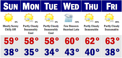
We have one more mild day before reality sets in again. Tomorrow will be a mild day, yet cloudy. There is a slight chance that we will see a few late afternoon showers or some drizzle out of those clouds, maybe some fog. Highs will generally be in the mid, maybe upper 60's after mild lows in the upper 40's. Friday will be a cold day with highs struggling to get to 50 degrees with a stiff NW breeze. Morning lows will be near freezing as well, so you will have to start up the car early to get all that frost off the front and back windshields. We will stay in this cool to cold regime for the next week or so after tomorrow with highs in the 50's for the weekend and then upper 40's for Monday before we will warm ahead of a cold front, propelling temperatures into the upper 50's and low 60's by midweek, next week. Before we get there, Boston will likely see its first freeze on Monday morning and the suburbs will likely fall into the low and mid 20's.

Of note, the GFS has backed off on the cold today progressively through the model suites, from 00z this morning to 18z this evening. Each has backed off the cold shot coming to the eastern and northern United States dramatically. However, the Euro is still going full force with this cold shot, of wintertime cold, so we will see if the GFS is just in a blip and had a bad day or if the Euro will start to turn more towards a GFS solution, warmer. We'll see. Thats all for now. A generally dry forecast and turning colder.

Tomorrow is November 1st. What will this month bring? Our first snow?

Tuesday, October 30, 2007

Trick or Treat Forecast

We have got ourselves another great looking Halloween this year, just like last year. Highs tomorrow will be quite warm, getting all the way up into the mid and upper 60's. A few spots in southwestern CT may come close to 70 degrees by say 2-3PM tomorrow afternoon. By the time trick-or-treat time comes, say after 6PM, it will cool considerably as the sun goes down by 5:45PM, so early trick-or-treaters will have temperatures in the upper 50's, while if you wait until after 8PM, you will probably get low to mid 50's. Temperatures will gradually fall into the 40's during the course of the night, but likely only a few spots will dip down into the 30's. We still have another warm Thursday before afternoon showers arrive ahead of a cold front that will usher in some much colder air in for the end of the week and the weekend. We are talking about highs struggling to get into the low 50's on Friday and Saturday and then having temperatures in the mid to upper 40's, for highs on Monday with a chance of a few rain showers here in Southern New England, but these rain showers could mix with and change to snow showers in far Northern New England across northern New Hampshire and northern Maine on Monday. Actually northern Maine saw its first light snowfall this morning with Bangor seeing their first flakes of snow. Some spots saw enough to coat the grass and roadways, believe it or not, but it all melted by the time the sun came up for a few hours.

Thereafter, it looks like we could be on the verge of a very cold, Arctic air invasion, sometime later next week with a major November Arctic front pressing through the lower 48, dropping temperatures all the way to the Gulf Coast near the freezing mark for morning lows and places like Minneapolis and Chicago will likely see highs in the 20's and 30's with the threat for them seeing their first snows as well. We will see how this pans out as the GFS has been hinting at this for days now and the other models are starting to pick up on it as well. In about a week, we could be talking some snow around these parts as well, but that is a long way out and I won't get into detail about that. More tomorrow.

HALLOWEEN FORECAST

First Trick-or-Treaters (5PM)...............Sunny 59

The Regulars (7PM).................Clear 55

Late Night Trick-or-Treaters (9PM)...............Clear 49
_____________________________________________________________

I will have more on the trick-or-treat forecast today and just wanted to say how cool the Rolling Rally was today. The Boston Red Sox and our fans are truly classy people who know how to have a good time. I'm sure all classes were half filled in high schools and colleges around Boston today.

Also, I will have more on the developing situation with Tropical Storm Noel, as I have not really mentioned him, but it looks like he could graze southern Florida as a decent (60+mph) storm and then rocket into the Canadian Maritimes and have an effect on how much cold air we will see come out of Canada later next week. Everything is intertwined. The tropics and arctic cold. Only in November. More tomorrow. Goodnight and Happy Halloween for tomorrow.

Monday, October 29, 2007

Red Sox Rally, Halloween, Celtics Opener, BIG Week!

Congratulations Red Sox on another World Series win! I kept the faith and I'm sure many more diehard Sox fans kept the faith as well. You guys deserve it. Resign Lowell. The parade/rolling rally is tomorrow and the weather could not be more perfect for an outdoor nearly November event in the city of Boston. First of all we have one more cold night to get through tonight. The temperatures are already in the upper 20's and lower 30's in the suburbs of Boston at 9PM this evening and they are falling fast. There is a cloud deck coming in from the NW from New York state that will likely keep temperatures in check overnight so that we don't fall like we did last night. The lowest temperature in Massachusetts was a frigid 20 degrees in Norwood. Tonight, Norwood will fall to about 23 degrees. Overall it will be a few degrees warmer than last night, but you will still need the winter coat in the morning. We warm up to near 60 degrees tomorrow for the rally. Halloween still looks perfect with highs in the mid 60's and trick-or-treat time in the mid 50's. Then we cool down for later in the week back to where we were today.


RED SOX RALLY FORECAST

Boston, MA (12-2PM)


8AM................Mostly Clear 44


10AM.............Mostly Sunny 52


12PM Rally Time!..............Mostly Sunny 56


2PM End............................Mostly Sunny 58


4PM....................Sunny 53


6PM.................Mostly Clear 50


______________________________________________________________

Enjoy the day in Boston tomorrow. Its going to be another special day. I will have the hour-by hour forecast for the warm Halloween tomorrow. Its going to be perfect for the trick-or-treaters. I'm sure there will be lots of work done in Boston tomorrow.

Sunday, October 28, 2007

Red Sox One Away from Another Championship!

Red Sox nation is on a high tonight as the streaking Sox won another one tonight at Coors Field, 10-5, against the Rockies. They are now up 3-0 in the World Series. It looks like it is in the bag for another world championship coming to Boston and New England either tomorrow or early this upcoming week. The weather will be a grandslam as well with beautiful weather through the period and Halloween at this point looks to be absolutely perfect with highs in the mid and upper 60's for the trick-or-treaters. This time last night I would not have said that the temperatures would have been that warm. During the course of the evening, temperatures will drop from about 60 degrees at 5-6PM to the low 50's by 10PM. Before that, we have to face a cold Monday with high temperatures staying in the mid and upper 40's here in Southern New England. We are currently under a Freeze Watch for temperatures to fall below freezing for several hours on Sunday night and again Monday night and Tuesday morning. These won't be barely freezes, but hardcore freezes with temperatures getting well below freezing, into the mid and upper 20's. We warm up for Halloween and Thursday before we cool right back down for Friday.

World Series Game 3 Forecast

Boston @ Colorado (BOS leads 3-0)

8:00PM

First Pitch...............Mostly Clear, Winds SW-5 to 10mph; 48

Last Pitch.................Mostly Clear, Winds SW-Calm to 5mph; 41

BOSTON CELEBRATION (1AM)..........Mostly Clear; 38

CONTINUED (3AM).................................Mostly Clear; 32

So there you go. If you go out celebrating, just know that it is going to be a cold one. I don't too many will notice the cold out in Boston...the mass of bodies will make it feel much warmer, right? Or the booze.

Almost forgot.....

WEEK 8 FORECAST

Patriots v. Redskins

4:05PM Gillete Stadium

Kickoff...........................Mostly Sunny; Winds W-15 to 20mph, gusting to 35mph; 56

Halftime........................Mostly Sunny; Winds W-10 to 20 mph, gusting to 35mph; 53

End.................................Mostly Clear; Winds W- 10 to 15 mph; 48

____________________________________________________________________

Next forecast tomorrow. Go Sox and Pats!

Saturday, October 27, 2007

November Outlook

November can be a month of extremes here in Southern New England. We usually have wild temperature fluctuations with near record highs in the 70's one day and then the next could struggle to get out of the 30's. Boston, in the city itself, usually experiences its first frost in the first week of November. Also, since we have not seen our first flakes yet this season, I would bet that much of Southern New England will experience our first flakes this month. With the new timing change, we will turn our clocks back next weekend, the weekend of November 3rd-4th. This means that the sun will set at approximately 4:35PM here in eastern Massachusetts. This is both a good and bad thing as we will lose the hour of sunlight in the afternoon, but will gain that hour in the morning so that us early risers will not have to go to work and school in the pitch black like we have been doing for a long time, with the sun rising at around 7:20AM. So we got lots to talk about, the general pattern that sets up later this month usually determines what the upcoming winter will be like. If we get into a blowtorch, especially near Thanksgiving and an extended period of blowtorch, then we can bet that the winter will be another disappointment. We'll see. Here are the averages for Southern New England

Boston and its Nearby Suburbs November Averages_______________________

Boston.......November 1st 57/42

Boston.......November 30th 47/33

Boston's lowest temperature for the period is -2 degrees, set all the way back in 1875 on the 30th. The highest temperature was 83 degrees set on the 2nd. Boston will usually see its first snowfall this month with an average of 1.3" of snow for the month of November.

Bedford......November 1st 56/35

Bedford......November 30th 45/27

Bedford's lowest temperature for the month of November is -2 degrees as well set in 1989. It can still get warm with the highest temperature reaching all the way to 80 degrees set in 1994. I do not have Bedford's average snowfall, but Worcester, MA averages about 3.6" and Blue Hill, MA picks up about 2.7, so Boston's nearby suburbs generally see between 2-3" of snow for the month of November. Back in November 2004, many of Boston's suburbs picked up between 4-7" of snowfall in a clipper type snowstorm that would prove to be the beginning of a very snowy winter with much of SNE experiencing much above normal snowfall. Boston came in just shy of 90", while parts of Cape Cod, of all places saw over 110" of snow. That was a special winter.
____________________________________________________________________

That is it for now, many forecasters are calling for a warm winter here in SNE, so we will see what kind of pattern we get ourselves into by Thanksgiving. Hopefully they are wrong.

Go Sox tonight, its going to be cold in Denver for game three of the World Series, mainly in the middle 40's dropping into the upper 30's by game's end.

Thursday, October 25, 2007

The Chill Will Make a Return to SNE

Its pretty chilly out there this afternoon with temperatures in the mid 50's around SNE, under mostly sunny skies, after a rainy morning. Tomorrow will be another chilly day, but not a chilly as we will see later next week. Tomorrow morning sun will fade in the afternoon and clouds will thicken in the evening. After midnight, the chances of rain will increase and then we will see a general rainy day on Saturday. It will not rain the entire day, but generally, it will be a wet, damp, yet warm day with a gusty southerly wind. Highs could get near 70 degrees. Then that will all clear out on Sunday and we will see mostly sunny skies and temperatures about ten degrees cooler, mainly around 60 degrees. We step down some more on Monday with highs struggling to get to 50 degrees after morning lows in the mid-upper 20's in the suburbs and likely upper 30's in Boston. We stay rather chilly through the rest of the week and we will not see another mild Halloween like we saw last year with highs in the low 70's and trick or treat time in the 60's. This year, afternoon highs will get into the mid 50's and then by trick-or-treat time, temperatures will quickly fall through the 40's, before some showers may move in ahead of a very powerful front that will usher in the nation's first blast of wintertime cold. I see parts of Minnesota staying in the 20's for highs and by the end of next weekend, there will likely be lake effect snow coming off the Lakes in western New York state, with highs in the low 30's. Highs in SNE will likely stay in the 40's and low 40's at that. Could we be talking some snow for the northern mountains by the end of next week? Perhaps.

More on the forecast later and good luck to the Sox tonight.
Keep the Faith!!!!!

World Series Game 2 Forecast


Wednesday, October 24, 2007

World Series Game 1 Forecast

It's Wednesday. The first day of the World Series. For the next one to two weeks many students and workers in and around Boston that are Red Sox fans will be mighty tired in the mornings. Tonight is Game One and we will have our star Beckett face off against the Rockies' Jeff Francis. If I were a betting man, I would take the Sox in six games. Anyway, I'm not and here is the all important forecast for the game tonight. I have been a little nervous about the rain that was looming back in Pennsylvania and the Ohio Valley that was aiming directly towards SNE, but I think now that we have escaped the heaviest and steadiest of the rain. There will be more intermittent light rain showers around Fenway tonight, not causing any delays or cancellations. You will get a half hour of light rain and drizzle followed by an extended period of dry, but very brisk conditions for another half hour. The light rain will be very periodic. The game will be played. It will be very cool as well though, and there will be some wind to contend with too, making it feel extra chilly and World Series-esc, at Fenway Park to welcome the Rockies. Anyway, here is the breakdown of the Game 1 forecast at Fenway tonight.

WORLD SERIES GAME 1 FORECAST

Boston v. Colorado

Gametime: 8:00PM

First Inning....................................Few Light Rain Showers; Winds N-5 to 10 mph, 51

Midpoint.........................................Few Light Rain Showers; Winds N-8 to 15 mph, 49

End..................................................Mostly Cloudy, Brisk; Winds N-10 to 18 mph, 47

There it is. If you are lucky enough to be going to the game, dress appropriately. It is going to be a chilly night, but hopefully the Red Sox win will warm you up a little bit. Windchills by the end of the game will likely be in the low 40's, with that raw moist feeling, making it feel extra cold. Just dress warm and enjoy the game.

More on the chilly forecast later.

Monday, October 22, 2007

World Series Bound; California Ablaze

Our Boston Red Sox are in the World Series!!!!! What a great ten days it is going to be for us Boston sports fans. The first game is Wednesday night at 8:00PM and it will finally start to feel like fall in SNE. Temperatures during the game will likely start around 50 degrees and fall into the 40's during the course of the game. Lows overnight Wednesday and early Thursday mornining will be in the 20's and 30's in the suburbs. Lows will be around 40 degrees in the city of Boston. Thursday's World Series game two will go off without a hitch and even be a tad warmer, probably in the 50's.

All the while southern California is on fire and over a quarter of a million people have been evacuated from their homes in recent days. This has been a growing inevitable problem because southern California basically saw no rain last winter, meaning they have not seen appreciable rains in nearly two years which has caused the vegitation to dry and become fuel for these raging infernos, threatening homes and people's livelihoods.

I will have more on the California wildfires, the World Series forecast, and our own extended forecast which proves to get much colder than we are used to in the next couple of weeks, all tomorrow. Until then bask in the glory of the Sox winning the ALCS.

Sunday, October 21, 2007

ALCS GAME 7

Well, can you believe it? The Sox have bounced back from being down 3-1 just a few days ago and are now about the enter decisive game seven, winner of which, goes to the World Series against the Colorado Rockies. What a difference from the misery we endured in the Nation last year, when the Sox finished with just 86 wins. Anyway, Dice-K is going tonight against Westbrook, redux of game three. I think tonight there will be much celebration in the streets of Boston tonight, say around 12-1AM. Here's the forecast...

ALCS GAME 7

Boston v. Cleveland (Series tied 3-3)

First Pitch..................................Mostly Clear, Winds W-6 to 12 mph, 66

Last Pitch...................................Clear, Winds W-5 to 10 mph, 63

Celebration.................................Clear, Light Winds, 1-2AM, 59

If you are going to stay out late tonight in the city, expect temperatures to cool into the mid-upper 50's in the city by about sunrise, for you late party-ers. Lows in the suburbs will drop into the upper 40's, so just keep that in mind once you start home after a nice victory celebration all night. Tomorrow will be very nice, near 80, so if you are a little hung over from the "celebrating" call in sick and head to the beach. Why not? Baseball in October and the beach. What could be better? We cool down late week, but it could be worse, Denver got their first snowfall today, an inch in the city. Haha. Big night tonight and oh yeah, the Pats are INSANE.

Keep the Faith!!!!!

Saturday, October 20, 2007

A Great Night for a Sox Game Tonight

Perfect summer weather is still in the forecast for tomorrow and Monday, and Tuesday for that matter. This weather will be absolutely perfect, not like the warm weather we saw yesterday, when it was so digustingly humid out there with dewpoints around 70 all day. Nope, this warmth will be nice and refreshing. Highs tomorrow will be in the upper 70's to around 80. Tomorrow's record high for Boston is 79 degrees, and we could make a run at it. Monday will be a tad warmer with widespread highs around SNE getting over 80 degrees; mainly in the low to perhaps a few scattered mid 80's for highs. Is this Florida? Nope. Then we "cool" down for Tuesday with highs in the mid 70's and afternoon showers ahead of a cooler airmass when we wake up to temperatures in the upper 40's on Wednesday morning and then we will stay in the 50's, for highs the rest of the week, with lows getting back into the low 30's. I have yet to go below freezing yet this fall. Usually I have already gone sub-32 by the end of the first week of October and have had multiple sub-32 mornings, but my lowest temperature this fall season has be 37 degrees. We had a stretch of 3-4 mornings when temperatures were constantly in the upper 30's, so that helped bring on the fall foliage, which is absolutely AMAZING this year.

The game for the Sox looks great tonight with temperatures in around 70 for gametime and falling through the 60's during the course of the game. I will have the Game 7 forecast tomorrow morning, but here is the forecast for our 6-0 Pats in Miami, playing the 0-6 Dolphins.

WEEK 7 PATS FORECAST

New England @ Miami (1:00PM)

Kickoff.............................Chance Thunderstorms, (30 percent); Winds E-9 to 13 mph, 85

Halftime..........................Chance Thunderstorms, (40 percent); Winds E-11 to 18 mph, 88

End..................................Chance Thunderstorms, (30 percent); Winds E-6 to 12 mph, 86

*There is a slight chance of a cooling thunderstorm the entire game, so temperatures will drop into the 70's at any point if there is a thunderstorm with heavy rain and lightning and thunder. Other than that, the sun will be strong and it will be hot and humid with dewpoints running in the low to mid 70's. It will feel disgusting. A hard day to be running the ball a lot.

Red Sox forecast tomorrow.

Keep the Faith!!!!!

Friday, October 19, 2007

It Feels Like August Out There

Rain is starting to fall outside with a temperature of 72 degrees. The dewpoint is a stifling 67 degrees. It is the end of October, right? This wacky weather will continue for a little bit longer, at least the next four days. Tomorrow, all the rain that falls locally heavy tonight, totalling around one inch, will taper around breakfast, but lead to a mostly cloudy, dank, warm, humid day with temperatures in the lower 70's. This leads us into the forecast for Game 6 of the ALCS. I want to say that Saturday night, the skies will start to clear, the clouds will break, and it will be very warm for an 8PM gametime temperature for October 20th. It will feel more like Atlanta, GA than a playoff game being played in Boston. Here it is.

ALCS GAME 6

Boston v. Cleveland (8:17PM)

Schilling's first pitch..........Clouds breaking, Winds W-5 to 10mph, 62

Last Pitch............................Partly Cloudy to Clear, Winds W-4 to 8 mph, 57

After the win Saturday night, we will have perfect weather for Game 7 of the ALCS when "the man" Beckett will take the mound on short rest and send the Sox back to the World Series. Afternoon highs will be in the mid and upper 70's, but by gametime, 8:00PM, temperatures will be falling through the 60's. Monday will be more reminiscent of a mid summer's day with highs near 80 to perhaps 85 degrees! Anyway....

Keep the Faith!!!!!

Thursday, October 18, 2007

The Tale of Two Coasts

The tale of two coasts is that the West will be rocked my strong Pacific storms, that will dump feet upon feet of snow in the Cascade Mountains of Washington, Oregon, and even northern California the next few days. Heavy rain will be common from Medford, CA to Seattle, WA. We are getting our rain from a somewhat tropical system, infused with torrential downpours and severe storms that have produced many tornadoes all up and down the Plains. This will arrive tomorrow in a much weakened form with heavy rains associated with the frontal system that is a cold front, but with no cold air behind it as the wind will turn west and then eventually southwest on Monday, propelling temperatures into the low 80's by Monday afternoon, believe it or not! This will be a dominant feature for the next several to many days with a ridge in the East and trough in the West. A piece of cold air will move into parts of the Great Lakes and Northeast on Wednesday or Thursday of next week, but I think this will be a transient colder than normal airmass, which won't be all that cold with departures likely around -2 to -4 degrees. That would equivicate to the 50's for SNE, generally with 30's for lows, perhaps. This will only last for 2-3 days, maybe 4, and then I strongly feel that the warm air will surge right back into the Northeast and much of the Eastern United States for that matter.

The main pattern the next 1-2 weeks will be for a Ridge-East, Trough-West. Thats it; there will be minor swings from time to time where the East cools for a couple days and the West warms up for a couple of days, but the majority of the time will be the West being very cool and stormy with heavy mountain snows, and the East will have periods of frontal rains with heavy showers and thunder with temperatures above to much above normal. This pattern looks to last until at least Halloween. We will see, eventually, what November will bring in terms of patterns that set up. Winter forecasts look bad for snowlovers, at this point, but hopefully we can amend some of this as we get closer to November and winter forecasts come into better agreement. Forecasts made now are still too permature and preliminary to be seriously considered. But all the signs are there for an above normal temperature Winter and below normal snowfall winter season for 2007-8. We will see. This current pattern does not bode well for the future. Could it be foreshadowing the general pattern for our winter, which if it does, will be every bit as frustrating as the winters of 2001-2002 and 2006-2007.

I hope not. Until then, I'm going to KEEP THE FAITH and watch the Sox come back down 3-1 to advance to the World Series!

Wednesday, October 17, 2007

Record Warmth will Return to SNE, 80's?

Well, we are about to enter a gloomy, but warm, period of weather here in SNE. If you were observant this afternoon, you would have noticed some high altitude clouds moving in from the west. The thickened and now it is mostly cloudy out this evening in SNE. Tomorrow will generally be a mostly cloudy, overcast day, with some brightening of the overcast, but at other times, some light drizzle or rain showers will be possible in any given location. Temperatures will be very warm with highs in the low 70's. Expect an even warmer day on Friday with a mostly dry day, allowing temperatures to shoot into the mid and upper 70's possibly, with rain not developing until perhaps the late afternoon. (5-7PM) The rain will come down heavy Friday night with some scattered thunderstorms possible. I am thinking that many spots will likely come close to three-quarters to one inch of rainfall, helping with the moderate drought that we are in at the current time.

It should come to a gradual end, by about 9AM on Saturday with highs still warm on Saturday; mainly in the low 70's. We will be warm again on Sunday with the real warmth coming in on Monday when some spots will be challenging record highs. The record high for Boston is 83 degrees on Monday and I think that Boston will make it into the lower to perhaps middle 80's which will be absolutely amazing for the 22nd of October! The warmth should ease after Tuesday, back to the 50's and 60's by late week, next week. Hopefully a permanent return to fall and no more summer, at least the 80's.

ALCS GAME 5 FORECAST

Boston @ Cleveland (CLE leads series 3-1)

8:00PM Gametime

First Inning.........Chance Showers (50 percent), Winds S- 10 to 20mph....66

Last Pitch............Showers Likely (60 percent), Winds S- 10 to 20mph....65

*There is a chance of a rain delay at any point in the game. At the start of the game, showers should be ending before round two of the showers moves in during the late night hours, bringing a rainy Friday morning in Cleveland. There is a small chance of thunderstorms as well. This storm system will arrive in Boston on Friday night, with a chance of thunderstorms too.

Keep the Faith!!!!!

Tuesday, October 16, 2007

Warmer Times Ahead

Warmer times are on their way to SNE. Just one more day of real fall New England air, before some mild, moist air invades SNE. First let's talk about tonight. Once the sun sets right before 6PM, the temperatures wll plummet here from the 50's to 40's within a few hours. Then they will continue to drop overnight with our light winds and clear skies. We are talking about a morning like we saw yesterday morning, when Martha's Vineyard got down to 28 degrees. I see widespread lows in the lower 30's in Boston's suburbs with a few upper 20's in places like the cranberry bogs of SE MA, and Martha's Vineyard perhaps. This dry air will warm up quickly tomorrow, in some cases 30-35 degrees warmer from the morning lows. Then the clouds will move in later tomorrow afternoon and become quite thick on Thursday with a few widely scattered showers.

There will be a few more showers on Friday with a balmy breeze, boosting temperatures into the 70's. SW winds will bring in some rain on Saturday, heavy at times, for a period on Saturday late morning and early afternoon with perhaps 1-2" possible, cooler temperatures with highs around 70. We "cool" into the mid and upper 60's on Sunday before we really "bake" on Monday with highs getting back into the mid and upper 70's with a strong SW wind. At this time, Pittsburgh though Cleveland and West Virginia, temperatures will be approaching 80 degrees. I do not think we will hit 80, but a few spots will likely come close either Monday or Tuesday of next week. A cooldown later next week, we'll see.

SOX FORECAST

Cleveland, OH

Red Sox @ Indians 8:30PM (CLEVELAND LEADS 2-1)

First Pitch..........Mostly Cloudy, Light Winds (S-10) 66

Last Pitch...........Mostly Cloudy, Light Winds (S-10) 64

Hopefully Wakefield can save us tonight!

Sunday, October 14, 2007

Unpack the Shorts and T-Shirts for Later this Week

Just when you thought that you could pack away all your summer wear and light clothing, you will need to unpack that box down in the basement and bring it back up. This diagram to the right shows that we will still need our fall weather gear for the next 2-3 days as highs will come up into the upper 50's with lows down into the 30's for many areas. However, that high pressure area will move off the Mid Atlantic coast by midweek and position itself near Bermuda by the end of this upcoming week. It will be a "Bermuda High." Famous for SW winds and warm temperatures for SNE. The warmth will start Thursday, but really work in here on Friday. Ahead and right before the warmth ends, there will be some heavy rainfall, periods of heavy showers that look to be on Thursday and perhaps again sometime next weekend. Highs on Friday look to be very warm with highs getting up into the mid and upper 70's in Boston. If you head a little farther south, NYC will be pushing 80 degrees again and the Capital will be in the lower to middle 80's, feeling more like mid-late August than mid-late October.

Interesting to note, Boston's low temperatures by the end of this week will come up to around 60-65 degrees, which is more in line with our average high temperature this time of year. I want to say that we will cool down to more seasonable levels by the end of next weekend, after experiencing highs in the 70's on Saturday again and cooler Sunday. But this year it seems like the warm spells last a lot longer than the computer models initially forecast several days out. We will see. I have yet to hit the freezing mark yet this season. All the plants are still very much alive in my backyard, now the fall foliage is starting to make it look more like fall, but that is mainly do to the declining sunlight during the days.

Good luck to the Pats this afternoon for their deul in Dallas. Red Sox, well, we'll do better tomorrow, just don't let Eric Gagne pitch anymore. All right, Tito?

Saturday, October 13, 2007

Seasonable October Weather

We will be experiencing seasonable October weather for the next week or so with temperatures, seasonably cool, mainly in the upper 50's for the next couple of days, going through Tuesday. Lows will get down into the 30's for much of the suburbs and sheltered valleys. However, I do not see widespread frost and freezes for all of SNE. Last night I hit my lowest temperature of the fall, 37 degrees. Allergies are still a problem, where I live at least. Maybe we can sneek to 32 degrees later this week. Rain will move in on Wednesday, mainly as scattered showers and will develop more steady later in the day. I'm am not talking about a washout, but there will be dampness and good mushroom finding weather with all the damp, misty cool weather we have endured the past several days. I'm sure there are some good wild mushrooms out there just waiting to be picked and cleaned. After the midweek rain, expect clearing conditions and milder temperatures.

The Sox looked great yesterday with their 10-3 win and look to make it a 2-0 lead tonight in the ALCS. BC, ranked number 4 in the country is taking on the fighting Irish this afternoon, looking to extend their great season to a record of 7-0. The weather looks fine in both places. It may be a little cool at Fenway with temperatures around first pitch (8:30PM) around 52 degrees, falling to around 47 degrees by midnight with the suburbs likely teetering around 40 degrees. Since the Pats are in a Dome Sunday, the weather will be 72 degrees and perfect.

GO SOX, PATS, & EAGLES!

Thursday, October 11, 2007

A Rainy Night

A coastal low pressure system is getting its act together just off the coast of Virgina and southern New Jersey this evening. It will deepen rapidly and rocket up NE to the Gulf of Maine by tomorrow morning, all the while, bringing in some tropical moisture from the Atlantic. Rainfall will start in earnest from SW to NE reaching Boston and Providence around 6-8PM. It will only last a good 8-10 hours in SNE and be heaviest in Maine and western New England. Here in SNE, rainfall amounts will be around a half inch. Further north into NNE, rainfall in the 1-2" range will be common. The sun will likely come out tomorrow afternoon with a stiff NW breeze, but temperatures will bump up into the low to mid 60's here in SNE, the warmest we've seen in a while. NNE will stay in the rain most of the day and have temperatures stuck in the low to middle 50's. It all wraps up Friday night for everyone and the first game of the ALCS with the Boston Red Sox facing off against the Cleveland Indians, will go off without a hitch. It will be a little cool and breezy with temperatures at gametime around 52 degrees, and likely falling into the upper 40's during the course of the game. Saturday may pop up a few instability rain showers in SNE, but in NNE, once the sun goes down, those rain showers will likely turn to snow showers, maybe allowing for a dusting of snow at Jay Peak. This weekend will be sunny but very cool with temperatures in the 50's South, upper 40's North. Great for playoff baseball in Boston.

Monday, October 08, 2007

GFS Calls for Northern New England Snow this Weekend!

The GFS is calling for weekend snow across parts of northern New England Saturday night and into Sunday with a coastal system affecting our area. First we have to get through many dreary days and one bonified rainstorm on Wednesday, with rainfall amounts approaching one inch of water, which is desperately needed here in SNE. Then we coast through the rest of the week mainly dry, but very gloomy with highs generally in the upper 50's to around 60. Then, you can basically flip a coin for the weekend forecast. The GFS computer model is the outlier which makes a forecast for a SNOW/RAIN mix for parts of northern New England later on the day Saturday, five days out. Not fifteen. This is getting into our view of managable time. However, none of the other computer models are calling for any type of snow involved in the coastal storm this weekend.

However, taken for what the 18z GFS is going for, we we see rain overspread all of New England during the day Saturday. It would quickly become heavy for all of New England with the low pressure system taking shape near Nantucket, deepening quickly. Then it would slowly move into the Gulf of Maine and this is when the GFS changes the rain to a period of heavy snow in the northern White Mountains and much of Maine. It looks like there is a timeframe of about 3-6 hours of seeing snowfall with temperatures very crucial, lower 30's. Even if surface temperatures were just below freezing, the snow would have a tough time sticking to the ground, plus we were seeing temperatures near 90 degrees even up there the past several days. It would all come to an end sometime Sunday, leaving all of us mighty cold.

We will need to keep an eye on this as it is the GFS. It will be mighty interesting to see what the NAM model is depicting tomorrow night at this time! SNOW is back in the forecast.

Sunday, October 07, 2007

"Gloom and Doom"

I hope you enjoyed our Indian Summer. Its over. No more 80's for a very long time. In fact, it may be a while before we see the 70's again. This forecast is looking mighty depressing for sun lovers. The lawns and plants will appreciate it, however. This is the coolest forecast I've had to make since April or May. After tomorrow, highs will likely stay in the 50's. First we will talk of tomorrow. There will be a few showers around, nothing heavy, just scattered showers with the frontal boundry around the area. The same can be said for Tuesday, just that the front will slip further south of our area, bringing cooler temperatures, around 60. More in the way of steadier rain tries to move into SNE on Wednesday, moving in from New York. It looks like we could get light to moderate amounts of rainfall, a quarter to half inch. That will all move out on Thursday with the same thing going on. Few showers with the front around our area, keeping temperatures cool.

All the while, an area of low pressure will be developing off the coast of Virginia and northern North Carolina. This will become a bonified Nor'easter during the day on Friday and move its way up the coast to deliver some heavy rain and northeast gales starting Friday night and ending sometime on Saturday. The precipitation may even end as a little mixed rain and snow in the highest elevations in New Hampshire and Maine on Saturday night and Sunday morning. After the storm slowly drifts into the Canadian Maritimes, cold air will funnel down into the Northeast for the end of next weekend, delivering our some of our first frosts and freezes here in SNE. I can't see highs getting out of the low 50's next Sunday, and that will be with mostly sunny skies, with the wind gusting out of the NW. It will finally feel like fall this week. No more summer, for a while.

Saturday, October 06, 2007

Falling Back into Fall

It seems that we cannot shake the summer. Today was another day of 80's with a seabreeze dropping temperatures at the coast today. Today will be the last real summery day for a while. I don't see any 80's in the next two weeks. Temperatures will be on their way down during the next week, day by day. First tomorrow we will feel cooler with morning showers associated with a cold front moving on through. Tonight, the showers have some imbedded thunderstorms with frequent lightning and thunder in parts of Upstate New York and Vermont. A rather ominous looking thunderstorm is ready to move into northwestern Massachusetts as we speak. Then we really start to cool down after Monday tries to warm up, but fails to do so. We are only around 60 on Tuesday and then we are down into the 50's, middle 50's at that with unsettled weather all the while. We may actually get some beneficial rainfall during the course of this week. A strong front moves through late Thursday to usher in some of the coldest air of the season on Friday with highs in the mid 50's and lows in the suburbs in the upper 20's to around 30 degrees. The end of the growing season in suburbia looks to be near its end. Get the last few tomatoes this week. It could be the last weekend for gardening. We'll see.

Until then, go Pats and go Sox!

Friday, October 05, 2007

Unsettled Times Coming

Unsettled times are coming to SNE after having some of the best weather of the year the past few days. Little noticed, Boston hit a record high temperature of 86 degrees yesterday afternoon, beating he previous record by one degree. Today is another warm one and so will tomorrow, in the 80's both days. Tomorrow is a beach day believe it or not. Then we start to cool down later Sunday with a backdoor cold front, into the 70's and dropping through the day. We really get entrenched in a NE wind on Monday with highs in the low 60's. Then storms will move to the west of us the entire week and we will be on the warm unsettled side of the weather with fast moving overcast skies, gusty winds and mild temperatures mainly in the low 70's with periods of rainfall. It will be unsettled, but mild. More on this tomorrow.

Wednesday, October 03, 2007

Let the Playoffs Begin

The Sox are starting up their World Series aspirations tonight against the Angels. The game should get off without a hitch. Temperatures will be around 70 and the sun is even peaking out through the clouds. The fog this morning was unbelievable where I live, visibility was no more than 100 feet at times. It all lifted by 9:30AM though. Now the sun is poking through. Tomorrow will be the first day of the warm weather with highs getting into the 80's. I have been outlining this warmup for a few days now and will not bore you with the details over and over. The forecast is pretty much the same as it was yesterday, just delaying the cold a day from Monday to Tuesday. Also, the Sunday forecast is a little bit in the air right now. Temperatures could be in the 80's or 60's, it all depends on the timing of a backdoor cold front. Likely, temperatures will start off warm for everyone and then later in the day the wind will shift at the coast and temperatures at Boston for instance will fall into the low 60's. Then its cool for Monday as the transition day, seasonably cool. Then we really feel fall Tuesday with highs in the 50's and lows getting below freezing in many suburbs, likely ending the growing season for good. If you can sneak by next week, consider ourselves lucky because the average first frost for Boston's suburbs is October 8th and Tuesday will be the 9th. We'll be on borrowed time. Boston doesn't need to worry until November 4th, on average.

Tuesday, October 02, 2007

What a Surprise! More Heat on the Way

Big deal. More summertime heat is on the way for this week. We saw it last week with temperatures in the 90's, so this week's heat will only feel like moderate heat to me and you. Highs will only nudge 90 or so three straight days, Thursday through Saturday. First lets talk about tomorrow for the big game. First pitch is set for 6:37PM and it looks like Fenway will see some drizzle and a NE wind, keeping temperatures in check, mainly in the 60's at gametime after highs in the low 70's. Then the sun breaks out on Thursday and the temperatures soar. No worries of passing 85 degrees in many locations. In fact, a few spots may nudge 90 degrees, but since the highest recorded temperature in Boston is 90 degrees for the month of October (ever!), I was a little hesitant of putting up the 90. Instead I went for the 89. Upper 80's will stay in the the forecast for both Friday and Saturday. Lows as you can see will come up from the 30's and 40's of the past couple of mornings, back to around 70 degrees, especially in the urban areas. Boston will likely stay in the low 70's for overnight lows on Saturday morning, a nice launching pad.

Then we will have to deal with a pesky backdoor coldfront with the timing of it very unknown that the present time. I could be off with it by a day, leaving Sunday mostly sunny with highs in the 80's, instead, I am going to meet the forecast half way and go for a high in the 70's with increasing cloudiness with a developing NE wind off the chilly water, only in the upper 50's now. Monday will be an exceptionally cool day with a raw wind off the cold water, keeping temperatures in check, mainly in the mid 50's for highs. Thereafter, it looks like we should stay seasonable, no more 80's, at least from what I can see after this approaching bout of summer weather. Enjoy it, it could be out last.

Monday, October 01, 2007

Summer Surges Back into SNE!

Welcome to October. What a time to be a New Englander. The Pats are undefeated going into Monday Night Football tonight against the Bengals, the Red Sox celebration at City Hall this afternoon for winning the AL East for the first time in 12 years is going to go off without a hitch and the playoffs start on Wednesday against the Los Angeles Angels of Anaheim. All the while, summer weather is surging back into SNE with temperatures getting back up into the 70's and 80's all the while. We return to beautiful weather tomorrow, an off day for Boston sports enthusiasts. Highs will get into the mid 70's in inland locations, while the coast will stay in the 60's on both Tuesday and Wednesday, with an increase in clouds on Wednesday with spotty drizzle from a NE wind. Gametime temperatures will likely be in the 60's under overcast skies, maybe brightening later in the afternoon. Then we are back to summer and highs in the low 80's on Thursday under mostly sunny skies. The abnormally warm conditions will continue through the end of the week and into the weekend. Can it get any better? Knowing that we are in October, I will be watching for the other shoe to drop soon, we will be paying for this 2 month stretch of near perfect southern California weather, I just know it.

I almost forgot, the Boston College Eagles are ranked #7 in the BCS polls this week! They are finally getting some recognition. Go Eagles, Pats, and Sox.