Sunday, April 29, 2007

"Normal" Spring Weather

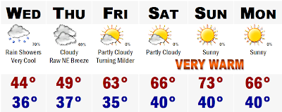
Rain showers are enveloping our region late this afternoon and will be with SNE through about 10PM this Sunday night. It should be very light stuff, just enough to make a few small puddles and wetten the ground. Most of it should clear out tonight, but there could be a few more showers moving in overnight and may stick around with us through about 10AM tomorrow with scattered sprinkles through the entire afternoon with a few sunny breaks that will propell us o the mid 60's, despite the mainly cloudy skies.

Tuesday drier conditions will be around and temperatures will be seasonably cool in the morning and warm up nicely in the afternoon to around 65 regionwide. Clouds will start to thicken and turn the sky overcast by 5PM ahead of the next light rainmaker. Rain should move in overnight Tuesday and last into the first half of the day Wednesday, similar to tomorrow's setup.

Dry and warmer conditions will end out the upcoming week, with seasonal temperatures in the 60's and maybe we can get to near 70 by week's end with mostly sunny skies. Perfect for yard work and maybe cutting the lawn for the first time this year?

Saturday, April 28, 2007

Thursday, April 26, 2007

A Rainy Friday

The rain is back tomorrow, but will be out of Boston by dinnertime, so that means New York City will be dry for hours prior and that means the Yankee/Red Sox game should be played.

Play ball!

Monday, April 23, 2007

RECORD HIGH OF 99 YEARS BROKEN TODAY IN BOSTON

We had a sneak peek at summer today with many of us getting into the 85-90 degree range away from SE MA and the South Coast. Today a record high of 86 was set in Boston, breaking the old record of 85 some 100 years ago. Don't expect this heat to last. Highs will be some 10-15 degrees cooler and then for the rest of the week we will be in the 50's with a chance of rain Wednesday night and again on Friday, which may be more widespread. A seasonable weekend looks to be on tap.

Sunday, April 22, 2007

A Hot Monday

After a beautiful weekend, we will embark on a beautiful first half of the week. Tomorrow will be the hottest of 2007 with many areas getting into the 80's for afternoon highs. Many places will top out in the lower to mid 80's with some cities right on the beach and South Coast probably staying in the lower to mid 70's, but move in just a mile or two and you are right back up to 80 degrees. It will be a high heat with extremely low humidity and gusty 30 mph SW winds that may spark some scattered brush fires. You know the drill. Be careful or just don't burn leaves or brush tomorrow while doing yard work and do not throw cigarette butts out of your car window into brush. All it will take is a little spark tomorrow and there will be some headaches for fire crews. For this reason we are under a FIRE WEATHER WATCH which will likely be raised to a RED FLAG WARNING for tomorrow. Tuesday will cool down a bit, but it will still be warm. Then it gets dreary for midweek on, but it does not look like the flooding rains we saw one week ago. It will be more nuisance light rains that will be scattered around. It will not be a steady rain that goes on and on for days and days that causes the rivers to go over their banks. Right now the time line on the rains is difficult to pin so I put a chance of light rain showers for every day, but as we get closer, the larger breaks between the rains will be more pronounced and forecasted. It should all get out of here by next weekend.

Saturday, April 21, 2007

What a Stretch!

The weather is absolutely perfect on this Saturday. Temperatures are much higher than any forecasted as its nearly 1:30PM and the temperature on my thermometer is reading 78 degrees. One reason for this extreme heat is the fact that the dewpoint is extremely low, as many areas only have a 10-15% relative humidity. Factor that with a light to moderate NW breeze and complete sunshine, the ground really starts to bake. Dry air heats up much more fast than humid air. Thats why you can get the deserts in the SW part of the United States to have days and days of high temperatures above 120-130 degrees, while parts of Florida will very rarely get above 95. Thats why today, Saturday, I think metrowest will likely top off around 78-82 degrees. Tomorrow will be a tad cooler with a more subtle breeze turning onshore and temperatures will still be warm, but only top off around 70-75 in metrowest and upper 50's to lower 60's on the coast.

We all warm up on Monday with highs soaring well into the 80's. Many forecasts are staying conservative with temperatures in the upper 70's to around 80, but I see all levels of the atmosphere really starting to get warm. This will allow the surface to have another catalyst in warming and add the factors that we are seeing today to heat us up, we will really heat up on Monday afternoon, with temperatures in the mid to upper 80's, with the warmest temperatures actually along the eastern facing shores, as there will be a strong SW wind that is a warming land breeze all the way to the coastline. It may be a stretch, but I could probably see somebody getting real close to the 90 degree mark here in the Boston area, but if Boston doesn't do it, the Mid Atlantic from DC to Baltimore to Philadelphia has a chance at the 90 degree mark.

Tuesday the warmest of the air heads offshore, but who is going to complain about middle 70's and mostly sunny skies. It will be a Top 10 Boston 2007 day. Then it gets more unsettled midweek with much cooler temperatures. We may get stuck in the 50's on Friday with a raw east/northeasterly breeze with a storm system scooting to our south. Overnight temperatures will likely cool down a bit by Friday morning as well as many outlying cooler towns will likely flirt with freezing once again after seeing low temperatures falling to about 60 earlier in the week.

If you are looking long range, it looks like we will be on the verge of very warm air and cooler springtime air, but it looks like we will mostly be very warm through the next 10-14 days with storms skirting our area every so often, but we don't have to worry about snow again until next winter. The warmth is here to stay, finally.

Thursday, April 19, 2007

The Sun Returns

The forecast is pretty much staying the same from yesterday. Today turned out to be a really nice day with many outdoor sports finally having the weather dry enough to return outside and stop all these cancelled games. Tomorrow will be another great day outside with highs getting back to around 60 inland with a sea breeze along the eastern facing coasts, only letting highs get to around 50-53 and then fall back into the upper 40's during the afternoon hours. Saturday is one step up with highs notched up a few degrees higher, into the middle 60's. Want another notch up? You got it. Highs in many areas should go over the 70 degree mark and everyone will be pushing the 80 degree mark on Monday, except the south facing coasts and Cape and Islands where the SW wind is a strong sea breeze, so they will only mark to mid 50's to around 60 degrees while parts of metrowest of Boston will be nudging the lower 80's. We will start to cool down on Tuesday, but it will still be a very nice day with highs reaching into the lower 70's and then we will watch a weak area of low pressure develop along a sagging cold front coming through the Great Lakes bring us some scattered showers and cooler rain cooled temperatures in the mid to upper 50's, but at this time it looks like most of the storm's focus will be in northern New England, but its still six days away so there is plenty of time to dry this storm up. Thats all for now, enjoy the dry weather and pretty soon, we will be basking in the warmth of the summer sun, on Monday. Finally. More tomorrow.

Wednesday, April 18, 2007

Skipping Spring and Heading Right into Summer

Tomorrow will be our last cool day with temperatures cooler than average in the upper 40's, but then the sun will come back on Friday and the warmer temperatures will be back. We first warm up slowly on Friday with temperatures reaching to around 60 and then we are in the 60's on Saturday and then we will be in the lower 70's on Sunday and then will max out to around 80 on Monday in many inland areas. The one problem will be the coast because of the fact that the water temperatures are only around 40 this time of year. I do believe that even the coast will be pushing 80 on Monday because there will be a gusty WSW wind, but during this weekend we will have a finicky wind that will likely transition to a sea breeze right along the coastline and will likely make temperatures drop a good 10-15 degrees below the numbers you see on the forecast. Early next week, however, we will all bake, except the south facing coasts where a WSW breeze is a sea breeze, so they will be markably cooler with highs likely to be around 60, which is much better than the 4-5 day stretch we have been dealing with with highs in the upper 30's to lower 40's and constant rain. The end of this stretch is near and we will be skipping nice springlike weather and head right into a nice summertime stretch. Enjoy.

Tuesday, April 17, 2007

Warm Temperatures Only Days Away


Some Snow Today

Putting it out there that many of us will likely see some snowfall today if you already haven't seen it this morning. Parts of Worcester County have already seen some snow today accumulation up to a 1/2" as well. More is on the way for today. All of us are fair game for some wet snow today even down to the coastline. Right now I am watching a rather intense band of precipitation pivoting into NE SNE at this time from Maine and will likely be here by noon. With the atmosphere so much colder today, this heavier precipitation will likely mix with and change to snow and sleet in SNE. I wouldn't be surprised to see some light accumulations on car tops and grassy surfaces, especially in Worcester County where they have already seen the snow. GFS is computing that as much as 1-3" is possible outside of Route 495 today with up to 4" in SW NH. We will see, but the threat is out there today and real.

Monday, April 16, 2007

Hold Out Just a Few More Days for the Warmth


An Amazing Storm

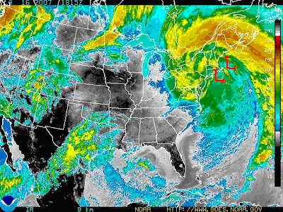
What an amazing satellite picture of this storm. I found that the lowest pressure of this storm system was at 968mb. To give you some perspective, that is a the general pressure of a Category 1 Hurricane. And in fact, some places did see hurricane force winds. The highest SNE wind gust that I could find was 80 mph and that was on Blue Hill. Many other areas, even inland areas, saw wind gusts between 55 and 65 mph. The storm began with a quick dump of snow in western MA which totaled up to 8" in Cheshire County and even northwest Middlesex county saw up to 2" of snow. Then it was the rains. Rainfall totaled between 3-5"+ and more is possible through Thursday as this storm will just sit and spin south of SNE through the period until it decays and moves out. In fact, tomorrow colder air will loop in as the storm sits off the Cape and we will likely see a rain/snow mix even down to the coastal plain. Don't expect any accumulation, but it will be nasty. The worst of the storm is over however. The good news is that springtime weather is only a week away and I will have those "warm" details out within the hour.

Saturday, April 14, 2007

Major Downgrading

Both models came in much warmer in the 18z suite and made me drop totals drastically.

First Call on Storm

We are about 20 hours away from the storm getting its act going in New England and I am puting out my first call on snowfall accumulations. As you can see, they are quite significant in western New England. Out in southern Vermont and much on central New York state, accumulations will likely be in the 8-16" range with higher amounts about 1500'. In extreme northern Vermont, New Hampshire, and Maine, there will probably be a heavy wet accumulation of 14-24" of snow with up to 30" in some of the highest peaks above 2000' to 2500'. Coming closer to the coast, SE, accumulations will dive to around 3-6" in western Massachusetts and much of southern New Hampshire with perhaps 1-3" north of Worcester and Springfield. Fitchburg may see a quick inch or two before even here it flips over to a heavy pounding rainfall with temperatures in the mid to upper 30's. A small portion in NW Rhode Island, their hills, may see up to an inch of wet snow as well that will likely be washed away.

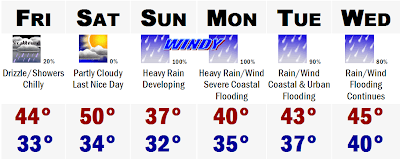
The snow will not be the only player. The rain, the wind, and the coastal and urban flooding will be major stories in SNE. First the rain will fall heaviest tomorrow afternoon and tomorrow night through early Monday morning. All said and done, I am thinking that around 3-6" of rain is possible in the green shading where it stays mostly rain. Easternmost places will likely be closer to the 6" amount with SW CT likely closer to the 3-4" of rain, which could still cause some urban and basement flooding. Streams and rivers may also come out of their banks as we will have the heavy rainfall all at once and we will have runoff melting from the north get into the larger rivers that will worsen the flooding on some of our larger rivers. If this were to change to a mainly rain event for CNE and NNE, we could be talking about major river flooding, but I think we will put this problem to rest as they will add on to their snowpack. Coastal flooding could be very bad on the east facing beaches and if you are in a place that normally floods in strong Nor'Easters, I would make plans to have the pump ready, sandbags, and be prepared to evacuate if conditions warrant.

The wind will also be very bad during the height of this storm later tomorrow afternoon and night. Winds will gust to around 50 mph in inland areas of SNE during this timeframe and will be gusting to aroud 60-70 mph on the eastern beaches and highest hilltops like Blue Hill for example. This will likely bring down tree branches and possibly power lines, so scattered power outages will be likely during this timeframe which could make it a cold miserable night for many in the dark.

We may get in a dry slot for the Marathon on Monday with the storm stalling out in extreme southern SNE. This will likely bring all the heavy rains and snows to our north and northwest and give Boston a nice dry slot with easterly winds not nearly as gusty, only gusting to perhaps 30 mph from the east, which is bad, but not nearly as bad as 70 mph from the east that we will have Sunday night. The Marathon will likely feature cloudy skies with drizzle and temperatures starting the race around 38 in Hopkinton and ending the race around 43 in Boston.

This storm will sit and decay for much of next week with a chance of showers of both rain and snow in SNE with temperatures in the upper 30's to around 40. The same thing can be said for Wednesday before we finally start to shake out of this storm's grip and get some sun on Thursday with temperatures rebounding to around 50 and then we may see 60 again on Friday and possibly warmer thereafter. We'll see. So far its been a miserable spring.

More on the storm later.

Thursday, April 12, 2007

Possible Historic April Storm Looms...

My snowfall forecast for this storm today pretty much worked out, but I don't think that the snow accumulated 1-3" outside of 495 in places like Acton. If anyone has observations from there, let me know. For inside of Route 495, it pretty much stayed an all rainstorm with heavy rain at times, but at around 2:30PM it turned wicked heavy and turned to sleet and briefly snow where I live and accumulated to a skim coating on the cars and dirt.

This storm is all done so lets look ahead and I am not going into any details with this storm once again because it was heard getting all the details fo this storm 12 hours out. This storm is still 3+ days away and it would be irresponsible to give any specifics. One thing is that this storm could be one of the biggest to affect the entirety of the eastern seaboard for quite some time and be a storm that will live in our memories for a while as well. Coastal residents should prepare for major to perhaps catastrophic coastal flooding from this storm. Start thinking about your plan of action now so you will not be caught off guard. Right now if my arm was twisted and I had to tell you what precip type most of SNE would see, especially eastern SNE, I would say that we would face heavy rains with sustained winds of 40-60 mph along the coastal plain and 30-40 mph just inland. Power outages, even without the snow, could be a real possiblility here on Marathon Monday. Tropical storm force winds are nothing to sneeze at and wind gusts could very well approach Hurricane Force levels of 70+ mph. And here I go, getting into specifics, so I will stop talking about this and say to stay tuned to the weather the next several days.

This could be a biggie.

Tuesday, April 10, 2007

Storm has Trended Much Warmer for SNE...Another Major Snow for NNE

This afternoon the models went to a mostly rain solution for SNE, after yesterday showing much of SNE receiving an easy 6"+. Now we may see a good 1-3" of rain. All the snow will likely stay into CNE and NNE where there are already Winter Storm Watches in effect for heavy accumulating snows. Boston and Boston's suburbs will be all rain out of this one. Sorry, I was looking forward to watching the snow fall too. It may start as a brief period of snow that may accumulate 1-3" out towards Worcester, but that too will be washed away. NNE, the White Mountains into the western mountains of Maine may see the bonanza out of this storm yet again with many areas picking up in excess of a foot of wet snowfall that may cause power outages.

Monday, April 09, 2007

Belated April Fool's Joke for SNE?

Many of our models are starting to come together on a possible very snowy solution for SNE this Thursday. I don't want to get too much into it because with one pass of the models this thing could vanish, so just stay tuned...this could be the biggest April snow we have seen in SNE in many many years.

Saturday, April 07, 2007

Winter Plans to Strike Back

Winter is making itself heard today after depositing 2-4" of snow to the Mid Atlantic this morning and it is currently snowing in much of Texas. The storm that hit the Mid Atlantic is going to head off to our east and not really affect SNE, except that the Cape and Islands may see a few snow showers and flurries. Flurries will stay in the forecast for tomorrow before we clear out for Monday and temperatures will get back to around 50 degrees and we may be in the 50's for the Home Opener on Tuesday, but a sea breeze may develop dropping temperatures at Fenway to around 45. Then it gets MIGHTY interesting around here with the potential of a MAJOR WINTER STORM for the Northeast late week. I am not getting into any details right now because its still a ways out. More on this later.

Friday, April 06, 2007

Cold Pattern Continues with More Snow Possibilities


A White Easter in the Mid Atlantic and Texas!

The Mid Atlantic is bracing for one of their biggest snowstorms this 6th day of April. Can you believe it? The storm that will deliver this blow of wind and snow to the areas south of DC is actually a spitout of the storm that pounded New England yesterday with 1-2 feet of snow. More energy will rotate around the upper level low and spawn another storm off the Virginia coast that will really start to get its act together quickly and rotate bands of moderate to a period of heavy snow for areas in blue. As you can see, areas in the blue shading could be seeing 3-6" of snow out of this one. Somebody may see a half a foot of snow way down there and that just shows that the atmosphere here in SNE will still be able to deliver a good sized snowstorm for us. That may likely come next week, but again I don't want to get ahead of myself. This storm on the past 2 model runs has pushed a little closer to the coast and now gets the Cape into the action and one model even gets the South Shore, just SE of Boston into the game with a touch of light rain and snow. Most of the precipitation would fall in the form of snow, according to me, but since it would fall during the peak daylight hours, it would probably melt on contact, except accumulate on the grassy surfaces and car tops. Latest guidance is showing that an inch or two of wet snow could accumulate east of the Bourne Bridge. I will wait for the 18z models to come in, but extreme SE SNE could be seeing a blanket of white on the ground by tomorrow night.

Think the Mid Atlantic snowstorm is whacked, wait until you hear what else is going to be happening tomorrow. A storm will be taking shape over the southern Plains and dive into western Texas tomorrow and pull down cold air from the atmosphere, generating its own cold source and depositing a fairly significant snowstorm to western Texas. Many areas could be talking about a healthy 3-6" snowstorm, but places like Amarillo may pull off an isolated 8" amount. That storm will dive into southern Texas and bring cold air to all areas north of San Antonio and Austin, which may even bring a period of wet snow and sleet to cities like Fort Worth and Dallas, TX! It has not snowed at all in April in Dallas in over 50 years. This is just unprecedented! That storm will push off the SE coast on Monday and as it pushes off it will have enough cold air to work with to give the eastern Carolinas some snowfall. Someone on the beaches of southern North Carolina or northern South Carolina may see a healthy 1-3" of wet snowfall!!! Charleston, SC may have enough dynamics working for them to pull off a flake or two as well. Have the seasons switched on us or something?

Basically, I am just telling you of all these freak snow events that will be happening in the next 3-5 days because it just proves my point that it can snow in the middle of April in Boston. Heck, it can snow well into the month of May, so I would advise anyone in SNE, not to put away those shovels or snowblowers because I have a sneeking suspicion that Old Man Winter isn't done with us just yet. Next week looks to be a very interesting week that will feature lots of storminess and abundant cold air available. If these two elements match up, beware, there is going to be a whole heck of a LOT of snow somewhere next week. Will it be SNE and Boston? Still too early to tell, but it will be wicked fun to watch what happens.

Thursday, April 05, 2007

Winter Chill Dominates into Next Week!

Our winter chill will dominate the next 7-8 days at least with overnight lows in the 20's and daytime highs getting into the 40's. What a scene waking up this morning to my thick blanket of snow of around 2.5", with many areas in NE MA picking up between 3-5" of snow. Just across the border into NH, may areas saw a solid 6-10" with areas further north past Concord, NH up to Portland, ME and much of central Maine picking up a whopping wet 12-20" of snow! Sunday River has recorded nearly 3 FEET of snow since this Monday alone!

Is there any more snow in the forecast? Not in the form we saw it last night, but there will be snow showers and flurries in the North for the entire weekend and into next week as a broad area of upper level low pressure will pinwheel cold air into our area for the foreseeable future. By next week we may be talking about a major storm for the eastern half of the US, but that is getting ahead of ourselves.

An interesting sidenote, parts of Texas and the Mid Atlantic are bracing for some significant April snow. Parts of the TX panhandle may see up to 4" and Dallas may even see a few wet snowflakes mixed in with the rain tomorrow! Dallas, TX seeing snow this late in the season. Its nearly mid April! The Mid Atlantic, namely the Del Marva may be seeing their most significant snowfall of the season believe it or not tomorrow night! A low pressure system will be getting its act together right off the coast and throw back some Atlantic moisture into the cold air to produce some heavy wet snow. Right now it looks like someone in Delaware may see upwards of 4-6" of snow! That storm will miss us to our east and crash into the Canadian Maritimes and give Newfoundland a whopper of a storm over the weekend with blizzard conditions with snow likely totaling 1-2 feet.

Like I said, Boston may get into the act the middle of next week. Until then we can stay warm by basking under the "warmth" of another Red Sox win...

Tuesday, April 03, 2007

Winter Storm Watches for NH, VT, and ME

A winter storm watch has been posted for much of VT, NH, and all of ME except eastern portions of the state. Here, it is looking likely that there will be significant snow and ice (sleet) accumulations to the tune of 6"+.

I will be posting my final forecast and snowfall map tomorrow afternoon after baseball practice, so stay tuned...

Sunday, April 01, 2007

Coldest Forecast in a While

Happy April Fool's Day everyone. My forecast is no joke though. We are about to enter an early to mid December winter pattern with highs struggling to get out of the lower 40's with a stiff NE breeze most of this week. Today is the last normal spring day with highs approaching 60 at this 1PM hour. Tonight the rain is moving in for all of New England and will become heavy at times for much of us. All said and done, we will likely see up to an inch of rain in SNE, but in Maine there may be some accumulating snow tonight as the rain transitions to snow overnight with cold air draining into the six state region for the entirety of the upcoming week and perhaps beyond. With regards to the snow in Maine, NW Maine may see anywhere between 3-6" of snow tonight, especially in the higher elevations with 1-3" possible in Augusta and Bangor. That will be quite a shock to the system waking up tomorrow moring in Maine to a fresh blanket of white on the ground with highs not getting out of the lower to middle 30's up there tomorrow. It is going to be miserable New England spring weather at its best. The snow will redevelop in Maine overnight tomorrow night and deposit another several inches of snow to the state and NW Maine in the highest elevations could wind up with 9-12" of snow with 3-6" possible in much of the rest of the state.

The cold, rain, and snow does not stop there. Tuesday we may see a break with drizzly conditions and temperatures in the 30's North and 40's South. Wednesday could get very interesting with a storm developing along the eastern seaboard and could be making its way up the coast to deliver much of New England a swath of heavy wet snow. This will be something to monitor, but for now I am going for mostly rain in SNE for it is April now and snow is not usually favored, but this year I would bet that my lawn up here NW of Boston will be snowcovered once again before summer truly settles in with highs in the 80's the latter half of this month.

Before that, our chances of snow do continue with 2-3 more shots at potential significant winter weather events from late week on through the week after Easter. We could have snow on the ground for Easter. Wouldn't that be amazing!

More on this cold springtime weather later and I will have any developments on the possible snows this week and beyond in the upcoming posts.